Friday, May 15, 2009

Day 40 - Off the Trail with Fingers Crossed

(2nd Effort. Much to my aggravation, the first one disappeared just as I was finishing it. Arrgh.)

Got up at 6:00, but Mark requested another half an hour, so we lounged 'til then before actually rousing. 48 degrees, high moderate overcast with a watery sun, still a chilly breeze blowing. Quick breakdown and on the trail by 6:55 - our fastest departure to date. Of the 7 people around the ponds, we were the first out. We were intending to do either 16 or 21 miles to a shelter. If we could make 21 miles, that would make the hike to Troutdale (Dickey Gap) around 16.5 miles, enabling us to get in on Thursday late afternoon. Otherwise we'll have to really hustle on Friday morning, to make the shuttle back to Trail Days in Damascus.

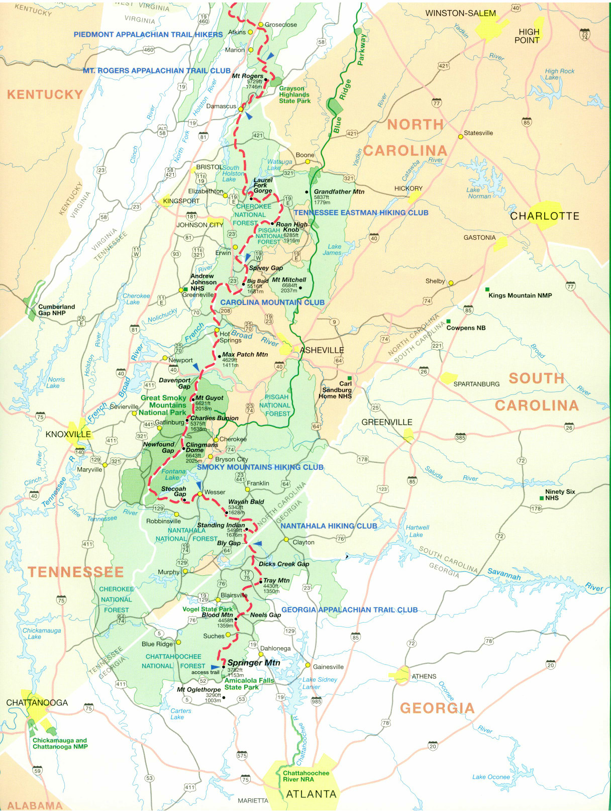
Breakfast after an hour on the trail. Various ups and down to VA 601 (or 608?), then a very long uphill to Whitetop Mtn, which is Virginia's 2nd highest point. Quite windy on the southern face that we were climbing - 15 - 30 mph. Most of the upper mountain was an old orchard, maybe apples. Finally made it to Buzzard Rock (or Rocks), offering some great views (Pete - sent a photo of this earlier today - got it - see above). Very windy here. Whitetop Mtn is poorly named - the actual peak is quite dark, almost black, due to a thick grove of evergreens, either hemlocks or spruces. Looks a little like Black Mountain at Philmont. The trail did not go over the actual peak, but rather around it to the right. There was an access side trail to the peak, but since we were trying to make 21 miles, and it didn't look like there'd be any view anyway, we passed on climbing to the peak.


This part of the trail was the roughest we had seen so far in VA, rocky and uneven, and Mark starting experiencing sharp pain in his left quadriceps, which got worse and worse as we headed downhill off the mountain. By the time we reached Elk Park (VA 600), he stopped and said he couldn't go any further. So we took an hour break at a campsite just off the parking lot there, and I massaged his quad and surrounding area, twice, to see if that would help. Several other hikers passed us during this time. We started up again on the climb to Mt. Rogers, but within five minutes Mark said "No Go," so we returned back to the park, intending to hitch back to Damascus or Abingdon, or at worst camping in place off the parking lot. Fortunately a guy who had just passed us (also heading back downhill) turned out to be an ATC member, and he offered us a ride to VA 58 - a good thing, because VA 600 was a sparsely travelled road, with scant opportunities to get a hitch back to any town. This guy (Nat; trail name Natty Bumpo) was doing short day hikes with his brother in law (Bill Norris) - Bill drove up to the peaks and walked down, while Nat climbed up to the peaks and drove down. So Nat was doing the climb to Whitetop, but would give us a lift as soon as he drove back down. Now that's "real" trail magic!


So we hung out, eventually putting on our rain gear against the chill and wind - the day finally got very nice - clear blue skies with a few fluffy clouds - but it was still pretty cold. Another group of 3 (including Captain Caveman, plus a dog) came down and also tried to hitch in; no luck there. I checked the parking lot kiosk and saw there was a hospital in Marion, which is where Nat and Bill were staying, at Hungry Mother State Park (in their RV). After about an hour and a half, Nat returned, and agreed that it made sense to take us to Marion. Since Bill was still on the trail, Nat then took the other group down to US 58. He returned about 20 minutes later, and we loaded up, literally one minute before Bill showed up. And so we headed off to Marion on 600, 58, and 16, all three very sharply descending, windy roads. Nat and Bill were very friendly, and we enjoyed the ride, chatting about various issues about the trail.


In Marion, we eventually settled on the Virginia House Motor Inn, nice place and not too pricey, plus fairly close to various restaurants and other useful places (pharmacy, WalMart, etc.) We got Nat's and Bill's c.p. #'s, and offered to treat them to dinner the next night, which they accepted (they chose a Mexican place near the hotel). After moving to our room, we quickly headed off to eat at the Pioneer, because it allegedly closed within the hour (it was 7:10 or so), but it fact they closed at 2:30 because of the recession. So we hit the only oher close place, the Mexican restaurant (Mi Puerta), in deference to Mark's leg - he was still hurting. Decent food. That took us till about 8:45, at which point Mark went back to the room and I headed off to the Magnusson Hotel across the street, which has courtesy Internet for the patrons of the Virginia Inn. Sent some brief emails to Pete and Pauline letting them know of our situation, then headed back to the Inn. Grabbed a much-needed shower, then called Marco and discussed various house issues. Hit the rack around 10:00, but Mark stayed up for Sports Center and some other programs. Plan is to see how a night of rest helps - or not - and then hit the hospital first thing tomorrow morning, while I do some blog reports at the Magnusson.


So, turned into another semi-nero, 11 miles and Whitetop Mtn. done, but obviously we are both very concerned about whether Mark can continue. Our fingers are crossed!
- Bob

Thursday, May 14, 2009

Day 39 - Damascus & Drying Out

Tuesday, May 12th - Got up at 7:20 or so to clear skies overhead, mountains still sheathed in fog, pretty cool yet. Got our laundry together and headed up the street to "Cowboys" - a combination restaurant and mini-mart. The laundromat was across the street, so after ordering breakfast I headed over and started our laundry. Priciest laundromat on the trail so far, but beggars can't be choosey, and we'd soon be personna non grata in the entire state if we didn't wash our stuff. We're pretty rank, so you pay the freight whatever it is.

At Cowboys, Mark got the Hiker's Special, but I stayed with pancakes, and gave the third one to Mark to augment the Special (which in reality wasn't all that much food, though it was cheap enough). We chatted with a local who had some knowledge of upcoming towns and crossings, learning about possible shuttles back to Damascus from the Troutdale area (where we plan to be in 3 days, when Trail Days gets fired up). I went back to the laundromat to switch our stuff to a dryer, then back to Cowboys. Other hikers showed up, and I spent a few minutes getting additional numbers entered into my new phone, including Gary's.

After about 1 1/2 hours, we both headed back to the laundromat and finished up there, then returned to the B&B, stopping several times to chat with other hiker groups we knew. Once back, Mark headed off to the Mt. Rogers Outfitters for fuel, then to the Post Office. I gathered my gear off the clothesline, re-sorted the rest of my laundry, packed, and moved everything to the front porch to free up the room. At 10:45 I headed back over to the library, but their Internet was down, so I returned to the B&B just as Mark was finishing up his repacking. We both weighed our packs, and came in almost identically, around 38 pounds each, with water and 3 days of food; not bad, but I suspect we'll be below 35 each when we lose the last of our cold weather gear; at least I hope! We both need to pay closer attention to how much food we have - so far we've pulled into each resupply point with a day or two (or more) of food remaining, and that's just weight for no purpose other than exercise. And I think we're getting enough exercise already!

We saddled up at 11:20 and headed to the end of town, where we ate lunch at a Subways. Then back to the trail (12:30 or so), which for the first mile was along the Virginia Creeper Trail (a rather famous bike trail down here). We promptly missed the turn-off for the actual A.T. (no double blaze!!!), so lost 20 minutes figuring that out and getting back where we belonged. At least it was a beautiful day by this point, clear and cool. We humped over two pretty stiff mountains, but it was considerably easier - the trails in VA are (in general) much nicer than in GA, NC, or TN - better graded, wider, and with more switchbacks. They have their rough spots, but it's so far easy to see why people say that the AT gets a lot easier once you reach VA.

We arrived at our intended destination (Saunders Shelter) at 5:00 pm, and met Frebird coming out just as we got to the access (side) trail. He indicated that there was a campsite with water another 2 miles down the trail, and since it was only 5 pm, we decided to continue on and make tomorrow's hike 18 or 23 miles planned) that much shorter. So we climbed yet another minor mountain peak (not bad since we were already up on the ridge anyway), then down to a gap, getting to the site at 6:15. Nice site under large white pines, reasonably flat. However, the water was from two rather stagnant looking ponds, which were unappealing, so I headed uphill past the upper pond and found the actual source, much better looking. Judging from the various trails, most people were taking water from the ponds, so maybe it's not so surprising how many people have been coming up sick these past 3 - 4 weeks. As I've mentioned before, a lot of A.T. Thru-Hikers could use about 2 years in the Boy Scouts; they'd be a hell of a lot better at basic camping skills.

It got chilly pretty quick once the sun went behind the mountains, so we ate dinner fairly quickly, hung the bear-bags, got a little cleaned up, and hit the rack around 8:30 or so. Freebird and another couple (Bark and Berry) shared the site with us, and there were two other single campers on the other side of the ponds. 11 miles today, in another semi-nero; not bad.

Day 38 - Rain and into Virginia

Monday, May 11th - Sent from the public library in Damascus, far southwest Virginia. After my report last night, it did in fact start raining again at 2:45am, arriving sudden and fairly hard. Lucky we had the warning from the weather band radio (and battened down the hatches before bedding down) or we'd have had a lot of wet gear before we could have gotten everything under cover. Rained on and off til about 7 am. We got up at 6:25, hit the trail about 7:05. It had been forecast to be an eventually sunny day, but in fact it was dreary, misty, and drizzley all day (still gray here at 5:30 pm). We had a much easier trail today, and it showed, as we covered 13 miles in just under 5 hours, including our breaks. That's our fastest speed yet on the trek. Means we hiked 50 miles in 2 1/2 days; not bad. Only real highlight on the trail is we crossed from Tennessee to Virginia at about 10:30 am. No state boundary there, other than a thin line of rocks, plus a sign indicating that we were entering the Mt. Rogers Recreation Area/Thomas Jefferson National Forest. I guess we were expecting more, like sunshine, birds singing, bands playing, pretty girls with laurels, you know (dream on -- not trail magic, but trail delusions?) .... Well, just more drizzle and mist, but nonetheless we're now in our 4th state, and past the 1/5th mark of the trek (roughly 470miles). And I suppose you could say we're now "home," even if it'sprobably 350 miles to Arlington from here.

Damascus - we reserved a room at the Montgomery B&B, very nice place.A little pricey, but all the less expensive lodging has been snapped upby other hikers planning to spend the week here for the upcoming annualTrail Days festival (60,000 people expected in a town with a populationof about 5,000). We will probably return for a day later this week,probably coming back from Troutdale, our next resupply point.

Did lunch at a Pizza Plus all-you-can-oink buffet, then bought food ata Food City. I personnally barely needed anything, having overboughtat Wal-Mart 3 days ago. Hit the Post Office for Mark's latest pickup(maps of VA), then the Mt. Rogers Outfitters (just a look-see), on theway back to the B&B. Hung some of my stuff on their clothes line(hopefully the rain is now over), and headed over to the library tocheck email (one each from Pete Davey and Pauline Clark). We'replanning at eating dinner at a nearby restaurant, Quincy's. I am stilllosing weight, and am now around 150 pounds. But the rate of loss hasdramatically slowed since I started forcing myself to eat more despitemy appetite saying "enough already!" Tomorrow we'll probably have anearly lunch and head on out immediately afterwards, doing 9 miles tothe first shelter north of town. So another sort of reverse "nero,"though 9 miles is not a trivial walk, and there are some very toughclimbs over the next three days, including Mt. Rogers, the VirginiaHigh Point, which we'll do this Wednesday afternoon. We hope to meetMark Barker and Mel Herrmann this Friday at Trail Days - it will benice to see some friendly faces from back home. Time to go!

Rest of report for 5/11:
The weather began to improve rapidly, to clear skies - quite a change. After reviewing the Weather Channel reports, I decided to put my various still wet items outside on the clothes line, including my tent, tarp, boots, and so on; this was around 6 pm or so. Mark followed suit shortly thereafter. Hopefully this will save us 1 or 2 pounds of weight tomorrow (wet stuff is heavy!) Once that was done, everyone in the house (including Gary (Happy), Jonathan Mauer (Blacklist, a former Life Scout from Troop 991 in Springfield), and Freebird (don't know his actual name) went over to Quincey's restaurant for dinner, also enjoying a duo playing a guitar and a fiddle; not bad). Dinner was very enjoyable, talking about the various oddball personalities we had run across since starting the trip. One of the sad things was how many people were dropping off the trail here, or at least so stating. We learned of dropouts at the grocery store, at the library, and even on the street, including many people we had been leapfrogging with for weeks. In some cases the money had run out, in others the enthusiasm was gone - maybe not surprising with all the atrocious weather over the past 6 weeks. Other people had been yellow-striping and/or slack-packing, another 2 clear signs of giving up. Trail Days has a big "Hiker Parade" on either Friday or Saturday, and so everyone so inclined can kind of take their bows to the cheering thousands and head on home. At 475 miles or so, nothing to be ashamed of. We spent about an hour and a half at dinner, then headed back to continue sorting gear. I hit the rack around 9 pm, but Mark stayed downstairs to watch the house TV, some Clark Gable movie on TCM, then something on the History Channel I think he said. I slept "OK" - as I think I mentioned to Pete on the phone a couple of weeks ago, a bed now seems a bit strange and uncomfortable to sleep in, compared to tent living.
- Bob

Wednesday, May 13, 2009

Day 37 - Nearing Virginia

Sunday, May 10th - Had a few spritzes of rain overnight. Got up at 6:30 am, 48 degrees,
windy, but reasonably clear overhead. We were tent camping on a saddle on a side trail several hundred yards down from the VanderLeer Shelter, which had been full when we arrived yesterday. The trail led another 200 yards further down to a water source, which I had
struggled down and back up from the previous night. Four other people camped on the saddle with us, one solo guy and a trio of girls (The Birds) in a 3-man tent. Not the safest campers we had seen, but having a fire the night before kept them safe despite cooking meals in their tents and hanging their bear bags over their tents.

We got going about 7:10 or so, with the long climb back up to the shelter being a tough start to the day. No one had left the shelter or surrounding area yet by the time we passed, so we're first out again. Found a plastic canteen about a half mile up the trail, and carried it (empty) in hopes of reunification, but alas, that never happened (we ended up leaving it in the Hiker's Box at the Mt. Rogers Outfitters in Damascus the next day). At 8:30 we stopped at a nice overlook for breakfast, could STILL see Lake Watauga - the thing is huge, we've been passing it now for 2 days. Had 4 bars on the phone - doubtless there's a c.p. tower somewhere above the lake - so I made a bunch of phone calls, including to my parents to wish my mom a Happy Mother's Day, and also to Pete Davey to let him know that I was back online again (as it were). Mark also called his mom and wife Brenda, and we finally made reservations at a B&B in Damascus (the Montgomery Homestead). We were lucky to get even that, as all the less expensive accommodations were already locked up for the entire week by people zeroing in Damascus right through Trail Days.

After about an hour we continued on, under bright, sunny skies, our best day in quite a while. The trail here was also much better than we had seen almost since starting the trek. Ate lunch at a memorial (possibly the gravesite???) of a well-known hermit who had resided here in the late 1800's/early 1900's; he died in 1923, and the memorial was erected in 1925. [Sorry, I have forgotten the name. -Ed. - His name was Nick Grindstaff, or 'Nick the Hermit'] This guy apparently made a fortune out west in the 1800's, was robbed of every penny, and returned to this area to live out his life in total seclusion. He was 72 years old. The memorial was built into the original chimney of his house. The rather stark epitaph read: "He lived alone; he suffered alone; and he died alone." I think I'll pass on that life-choice, thanks anyway...

Continued on past 2 shelters, both empty - we were trying for the Abingdon Shelter, 23 miles in, only 10 miles from Damascus. It is very small (5 spaces), so we had no expectation of sheltering there, but rather knew we'd have to tent camp. But it would be a water source, anyway. Passed several roads as we hiked, but no trail magic today, even though it was a Sunday - I guess we're getting greedy now after all the luck we've had with weekend Trail Magics. At one road crossing we found a hiking companion, Salty Dog (John); he was linking up with relatives for lunch. His cell phone (Sprint) didn't work there, so I let him use mine, and he was able to confirm his location with them (in fact they showed up just as we were leaving).

Another long climb after that, then rolling country to the first of several occupied campsites, which we continued past. We decided to fill up on water at a creek along the way in case we preferred or had to stop before we made the shelter. We finally ran out of energy around 7:00 pm, and took an unoccupied site about 3 miles short of the Abingdon shelter. And again, we expected the shelter and nearby tent sites to be a zoo anyway. So a 20 mile day, not bad, and "only" a 13 mile semi-nero to Damascus tomorrow. And also about 10 miles to the TN/VA border. After setting up and eating dinner, Mark turned on the weather band radio, and we were both stunned to hear that (despite the nearly clear skies overhead) we had a 70% chance of rain after midnight. So we completed a full camp setup, and once again battened down the hatches and got everything under cover. As it turned out, it started raining around 2:45 am, arriving suddenly and fairly hard. I must say, this rain sure is getting old! But as the saying goes: "No Pain, No Rain, No Maine." Well, we've had plenty of the first two so far!
- Bob

Day 36 - Wading the Appalachian Trail

Saturday, May 9th - Got up at 6:00 am to again check my email at the Hiker Kitchen, but
could not log on (found out later that Marco had used the wrong password the previous night, so I was locked out of my account til he fixed it). Did check weather.com, and saw that we had a large line of rain and thunderstorms coming at us, looking like it would arive around 8:30 or so. It was rather dismal looking outside, so it seemed rain was a certainty (again, sigh). At 6:45 I returned to our "cabin," and Mark and I finished packing up. I also finished boxing up the rest of our un-needed gear, and left it in the room with $15 cash for Brady to mail to my house at his leisure. All together, probably 5 pounds less stuff for us to carry.

Left around 7:40, and headed down for the trail magic at the "brown house by the A.T." In fact, we were the first to arrive, at 7:50 or so, but they were already ready for us. Quite a spread, with pancakes, bacon, hot muffins, fresh fruit, coffee, sodas, etc. One of the servers turned out to be the same guy that sold Mark his A.T. maps at Harper's Ferry last March; small world.... They were planning on serving three meals, all day long. Within 10 minutes about 30 people from the Kicora Hostel showed up, plus a few more straggled in from various nearby campsites. Oddly enough, many people were reverse hiking or slack-packing today, getting a shuttle out past Pond Mountain and returning for a second meal at the Trail Magic and another cheap night ($4) at Kicora. A few indicated they were going to stay at the Trail Magic all day (which I personally think is rather abusing the privilege). We left at 8:30 or so, with thank you's all around, and headed back out on the trail.

Very interesting walk - along the Laurel Fork creek, through some small gorges cut by the creek eons ago, past a really impressive waterfall, and along a creekside trail that was two foot or less wide, the cliff to one side and the creek on the other. Also past some neat flowering plants; some with very unusual colors. Then a very long uphill up Pond Mountain, pretty tough, especially near the top. Many of the slack-packers passed us on the way back to the Trail Magic (hustling right along, I will add). Grabbed lunch on top, with a partial view of Watauga Lake, a huge
TVA project lake. Since we had 2-3 bars, I went ahad and activated the new phone, and added the hundred dollar card while I was at it - but made no phone calls yet.

Headed down to Watauga Lake, where we ran into intermittent showers and an unexpected surprise to find that the trail was under water in about a half a dozen places. We managed to work around some of them, but in the end we switched our boots with our camp shoes and waded two stretches, the first of which was about 30-40 feet and up to my thighs. Sure wish I had thought to get THAT on camera: "Wading the Appalachian Trail" as the caption. Should have brought a fly rod. Took about an hour and a half to walk what should have taken 15 minutes - the hairiest part was avoiding the extensive poison ivy and briars during the workarounds. I think the local ATC has some work to do here....

Finally worked around to the Watauga Lake shelter (which we bypassed), and started climbing up to the dam, reaching it within about 20 minutes. Very impressive spot; we grabbed a few photos as we crossed over it on an access road. Then we had a VERY long uphill, tough going, to get up to the ridgeline again. Intermiitent rain and drizzle, very humid - quite a slog. We didn't bother with raingear, due to the humidity and still fairly high temperatures. I think Mark said it was about 7 miles of mostly uphill, with about a 3,000 foot elevation gain net; it took us almost 5 hours to finish it. Got plenty of great bird's eye views of the lake along the way. We did 17 1/2 miles getting to the Vandervaleer Shelter. The shelter turned out to be full, and the few campsites nearby were also taken (the ridgeline was quite narrow here), but the people there told us that there was a decent tentsite down about 300 yards along the trail to the water source, so we backtracked about a hundred yards and headed down a very steep and slick trail, and found the site, in a saddle on a connector ridge. Two tents already there, with a fire sort of going, but (barely) enough room for the two of us as well. The water turned out to be another 200 yards further down the draw, on an even steeper trail. I took care of that chore for both of us, and it took almost 25 minutes. Misty, increasingly windy, and chilly in the saddle, plus we were out of daylight, so it was a hurried setup and dinner, and a late bearbag. Amazingly, our fellow campers (a solo guy and a trio of girls) were cooking in their tents, and after waiting too long decided against hanging their bear bags at all (they WERE going to hang them above our tents at one point, til Mark said "I don't think so!") Fortunately the fire smell kept us all safe, despite their carelessness. In the tents around 9:15 or so. Long day!
- Bob

Tuesday, May 12, 2009

Day 35 - Phone Issues

Friday, May 8th, 5:55pm - I am sending this from a computer in Dennis Cove TN. I bought another phone at Walmart today, plus a hundred dollar card. Unfortunately no
service here so can't activate yet. Am charging up, and will attempt to activate tomorrow, and will call you if successful. I understand from Gary Alexander that my original phone has not yet arrived at your house. If still correct please call the Holiday Inn Express in Erwin, TN, and see if it ever went out. I suppose UPS may not have made a delivery there, and so they are still hanging on it. Who knows. At this point, the phone should be mailed to me at Troutdale, VA, which is the next resupply point after Damascus. We should be there in about a week.
I will try to get back on this computer late tonight or tomorrow morning very early. If you get this message please respond, and include the phone number for the faculty voicemail, so I can start sending updates again.
All is well here, but Mark and I are getting very tired of rain, rain, and more rain. Just our luck, it seems it's the wettest year in quite some time, at least according to the locals here. We finished 400 miles yesterday, and expect to be in Virginia (Damascus) late Monday or midday Tuesday. We're hoping VA will be a bit easier and drier than NC and TN. Seeya....
- Bob

Apologies ...

Folks,

My apologies. A combination of an emergency appendectomy for me and Bob's phone dying has backed up the reporting on this blog severely. Will endeavor to catch up over the next 3 or 4 days. Reports may not always be in order as a result!